LandSurveyCodesImport (LSCI) is a surveying plugin. Where modern field survey solutions are not suitable, it provides support for points processing taken in the field by converting them into drawings and GIS data in QGIS. For a more detailed presentation, we refer you to our previous article on this plugin.
Some users have asked us to facilitate the migration of their coding tool to LSCI. We listened to them and made some improvements.
New features
The main new feature is the archiving functionality, which becomes the backbone of the plugin. This is a major change and some adjustments are required for older users.
In previous versions, the source data was populated by the processing done by the plugin. If you wanted to have an unmodified file used for all procedures, you had to copy the source data to not overwrite it. The plugin did not handle this.
Now, the plugin uses the structure of the data and copies it to a selected folder (or the temporary folder of the QGIS processing toolbox) by adding the data. This has several advantages:
- You do not modify the source data
- You have an intermediate file that can be checked/completed
- You can archive it to indicate the concerned work area outside the master plan
- You can then proceed to one or more integrations according to your working methodology

Moreover, it is not uncommon for a software to have logs to know what exactly happens under the hood. In this case, for the codification, it allows you to know where a problem occurred with the codification entered.
We have therefore added a new line to select the logs to be produced, with a level to be chosen according to IT standards.
Aesthetic and qualitative improvements
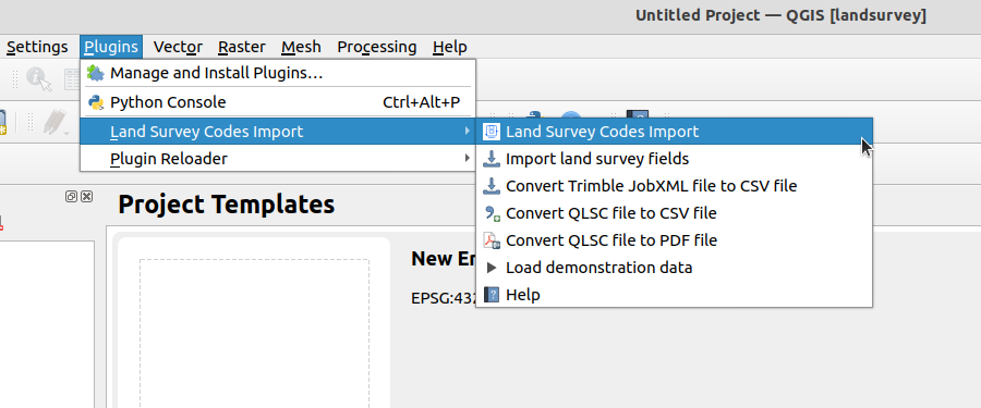
QGIS allows you to easily customize its interface. Nevertheless, it is sometimes complex to find your way through the different menus and buttons. For this reason, we have added shortcuts for the processing directly in the main interface, allowing less experienced users to find the main tools of the plugin in one place.
LSCI, like any such business tool, has a relative complexity. Without documentation, it is difficult to use. We have taken it to heart to improve it and to explain in detail each function.
This one is translated into English, and we hope to be able to do the opposite in the near future, to have English language as default in order to translate into other languages.
Finally, we took advantage of these new developments to further improve the quality of the code and to harden it.
Next actions
- Manage other input formats
- Add more coding tools
- Improving the export of the code list to PDF
At Oslandia, we are working hard so that you can free yourself from proprietary software to realize your surveying chain.
If you want to know how to achieve this or contribute to these tools, you can contact us by mail.

