Tag

OpenStreetMap

NewsFROpen SourceQGIS
vendredi 31 mai 2024

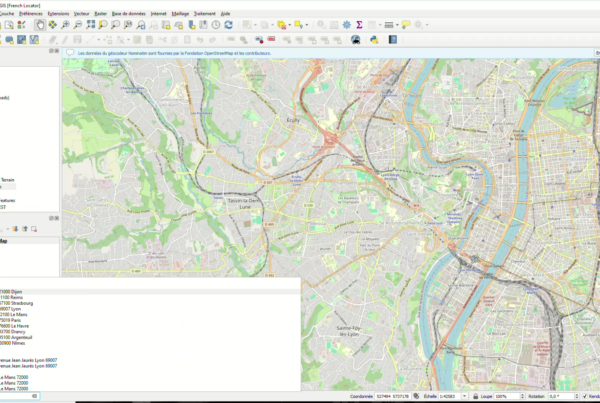
Plugin QGIS French Locator Filter 1.1.0 : API Photon et personnalisation avancée !

Avec près de 50 000 téléchargements depuis sa première version, le plugin QGIS French Locator…
Read More
NewsFR
jeudi 29 novembre 2018

Nouvelle collaboration entre Oslandia et l’Inria

Oslandia est spécialisée dans le traitement de données géospatiales et la science des données. Nous…
Read More
Data
mercredi 27 décembre 2017

OSM data classification: code release

After a set of blog posts published the last summer, we are glad to announce…
Read More
Data
lundi 14 août 2017

OSM data quality assessment: producing map to illustrate data quality

At Oslandia, we like working with Open Source tool projects and handling Open (geospatial) Data.…
Read More
Data
dimanche 6 août 2017

OSM user classification: let’s use machine learning!

At Oslandia, we like working with Open Source tool projects and handling Open (geospatial) Data.…
Read More
Data
lundi 31 juillet 2017

OSM user classification: the unavoidable metadata normalization

At Oslandia, we like working with Open Source tool projects and handling Open (geospatial) Data.…
Read More
Data
lundi 24 juillet 2017

OSM metadata description: the data behind the data

At Oslandia, we like working with Open Source tool projects and handling Open (geospatial) Data.…
Read More
Data
lundi 10 juillet 2017

OpenStreetMap tag genome: how are OSM objects tagged?

At Oslandia, we like working with Open Source tool projects and handling Open (geospatial) Data.…
Read More
Data
lundi 3 juillet 2017

OpenStreetMap data analysis: how to parse the data with Python?

At Oslandia, we like working with Open Source tool projects and handling Open (geospatial) Data.…
Read More