Credits: Pixabay (Pixabay Content License)
The Importance of Compliance
A geographic data layer must comply with many rules and constraints.
For example:
| Geometric | Topological | |
|---|---|---|
| Arbitrary rules | – no angles smaller than 15° – no polygons smaller than 0.3 m² |
– no polygons inside another polygon – no holes |
| Digitizing errors | – polygon with fewer than 3 points – single line in a multi-line geometry |
– duplicate node – self-intersections |
Checking the compliance of a geographic layer is an essential step in data validation, either to detect errors or to ensure that it won’t corrupt the information system into which it will be integrated.
When possible, being able to automatically fix these errors allows for a fully automated compliance-checking process.
What About QGIS?
The geometric and topological verification plugin is available to perform these checks using a step-by-step assistant.
After extensive work on code updates, processing creation, and method standardization, all these checks and fixes are now available in the Processing Toolbox!
Starting with QGIS 3.44, you can run these processes in batch mode and integrate them into a graphical modeler to create your own custom validation and correction workflow.
With 21 verification processes and 10 correction processes, it is now possible to create fully automated compliance validation chains.
They are available under the “Geometry Validation” and “Geometry Correction” categories.
The New Processes
Demonstration of detecting and fixing small polygons and small angles:
Custom Global Process: Demonstration
This makes it possible to create a custom treatment based on the available blocks. Here is an example of a model that checks and fixes small polygons and small angles.
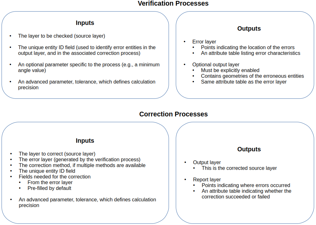
Input-output diagram of new algorithms
Each process follows the same input/output logic, making them easy to chain together in workflows.
And Next…?
The availability of these processing algorithms paves the way for improving tools like QompliGIS (link to the QGIS plugin), and for considering a web version where layers can be uploaded to be checked and repaired according to predefined, customized constraints.
Feel free to test these new processing algorithms. We are available to assist you, offer training on QGIS and geoprocessing, or to configure your compliance verification chain. Don’t hesitate to contact us at infos+qgis@oslandia.com