
We were a group of five Oslandiers at FOSS4G this year. We gave three workshops, and seven talks! Our workshops are available on GitHub, and the workshop VMs containing all the necessary software are available for download. People who couldn’t attend our workshops in Bucharest may be interested to go through the materials that we prepared, and run the workshops by themselves. If so please read on!
And thanks again to our friends in Romania. They did a wonderful job organizing this conference!
Creating web-mapping applications with QGIS Server and QWC2
This workshop shows how to publish QGIS projects to the web using QGIS Server, and create web-mapping applications based on the QWC2 (QGIS Web Client 2) JavaScript toolkit. More specifically the workshop shows how to set up and customize the QWC2 Demo Application (qwc2-demo-app).
The workshop material is available at https://github.com/Oslandia/workshop-qwc2.
PostGIS and QGIS meet in 3D
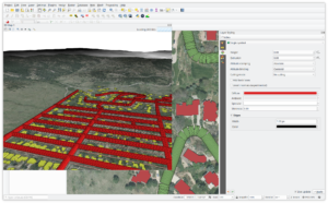
This workshop first demonstrates QGIS’ 3D functionality, showing how to display extruded 2D objects (building footprints), as well as real 3D objects (building roofs and walls). The workshop then shows how to insert and manipulate 3D objects in PostGIS, and display 3D query results in QGIS. The last part of the workshop covers the use of point clouds, and how to do data analysis combining 3D and point cloud data.
The workshop material is available at https://github.com/Oslandia/workshop-postgis-qgis-3d
Extraction, analysis and dataviz on open geospatial datasets
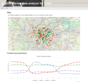
This workshop relates to the design of a complete geospatial data pipeline in Python. The workshop shows how to download the data from open data portals, and how to store it in a database. A simple machine learning use case is then covered. The workshop ends with the design of a Flask-based web application for visualizing the produced data.
The workshop material is available at https://github.com/Oslandia/workshop-jitenshea.